Municipal & Applied GIS
Production cartography, utility data management, and geospatial applications for a rapidly growing Arizona municipality.
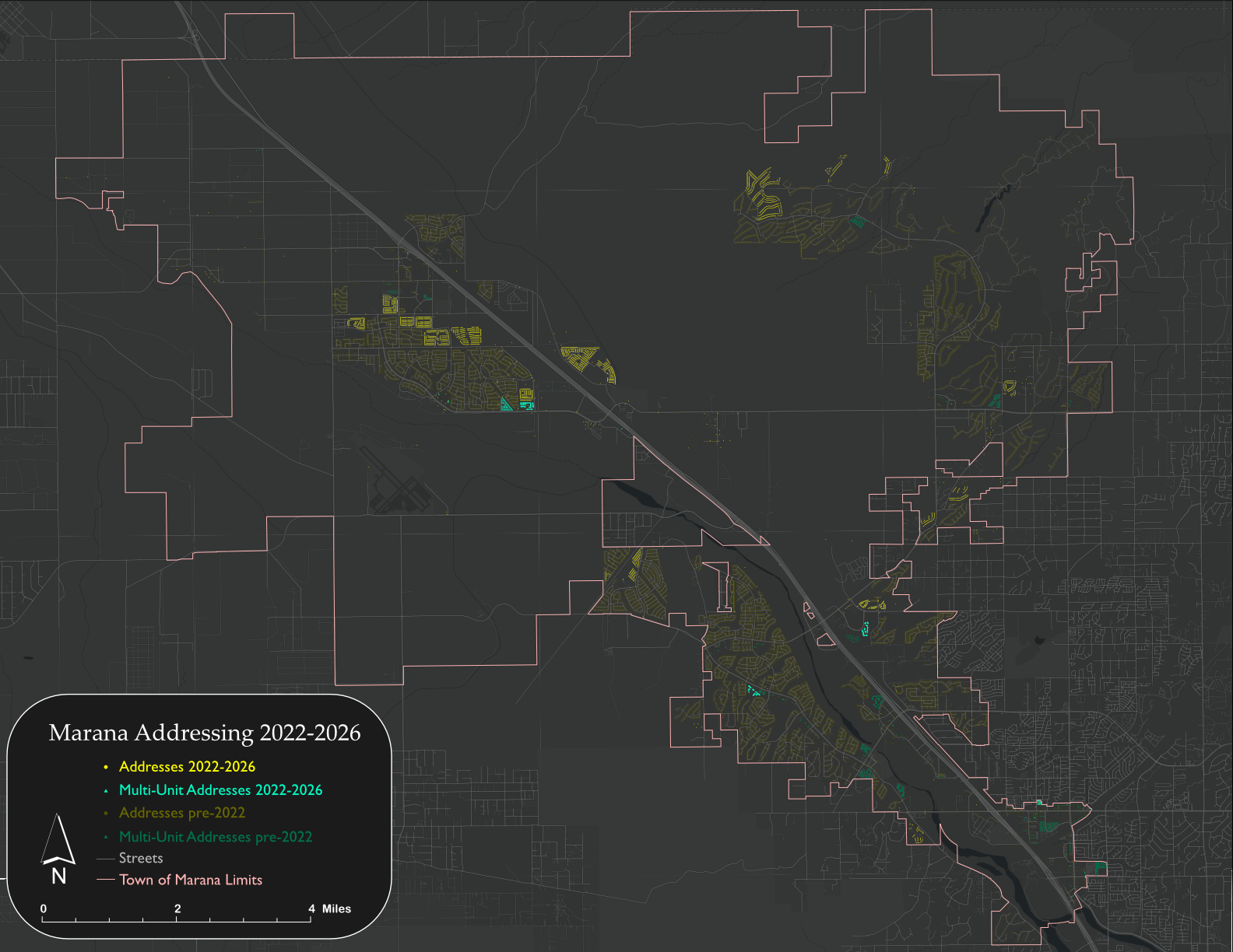
Addressing · Municipal GIS
Managing and maintaining the authoritative addressing database for Marana's rapid urban growth — coordinating across Fire, County, utilities, builders, and USPS to ensure data consistency across all agencies.

Town Reference Map · Cartography
With near-total creative control, I design large-format reference maps for Marana's meeting rooms and hallways — illustrating the town boundary, street hierarchy, trail networks, and river channels for a municipality that defies the car-dependent suburb label.
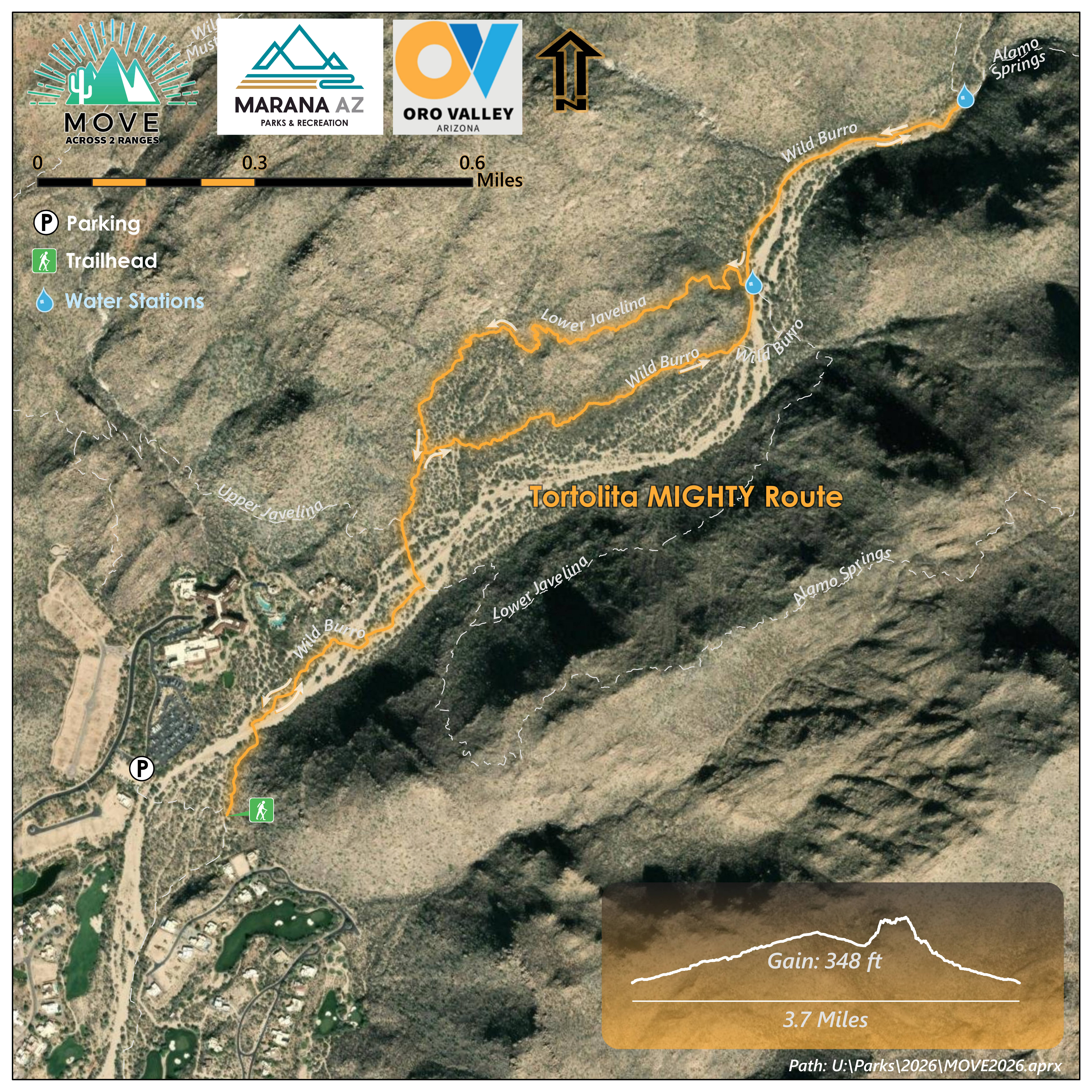
Event Cartography · Parks · Trails
Starting in 2023, I began doing the cartography for the MOVE Across 2 Ranges that happens every February. The event has four trail-difficulty choices, requiring a hike through the Tortolitas then the Santa Catalinas.
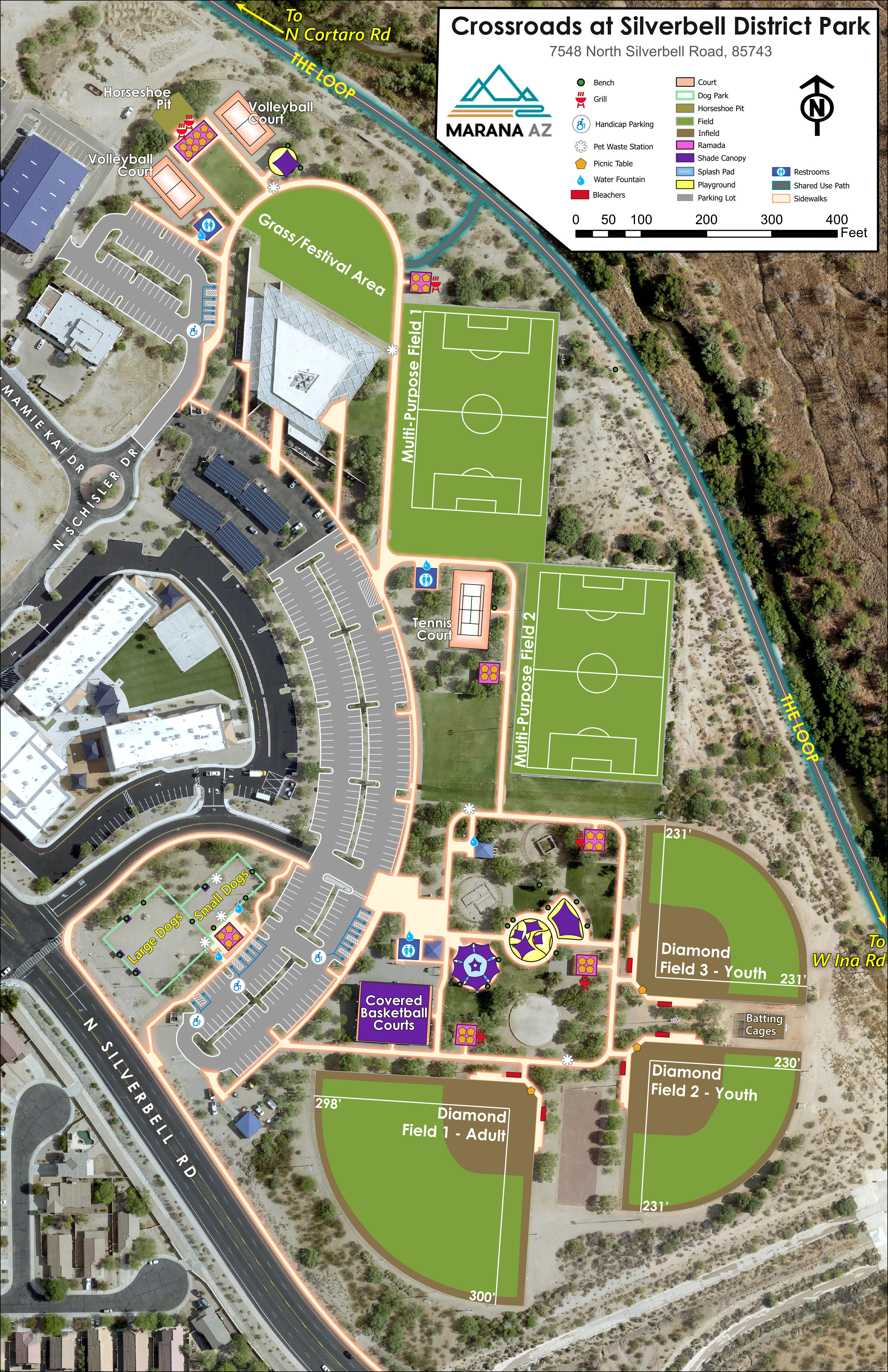
Cartography · Parks
I created maps of all Town of Marana parks. This required visits to parks where I compared old data to existing features. It was an excuse to bring park data up to date.
Cartography · Municipal Reference
The local post office asked for a large map print of Marana with zip code boundaries and all subdivisions. This is what I came up with.
Cartography · Municipal Reference
My first duty at the Town of Marana was to update the reference map for the town. I went with a plain phonebook-like map that attempted to show the basic features of a city.
PhD Research · EU Marie Curie Program
Publication-quality maps, terrain analyses, tectonic diagrams, and research infographics from doctoral research on the North Anatolian Fault system.
Scientific Article · Published 2020
Fluvial terrace dating and GIS terrain analysis revealing 540,000 years of unsteady rock uplift history along the Filyos River Gorge, Central Pontides. Published in Tectonics (Wiley / AGU), 2020.
Fluvial Geomorphology · Published 2021
OSL and cosmogenic dating of fill terraces and alluvial fans revealing the role of climate, hillslope processes, and aggradation in masking tectonic uplift signals. Published in Geomorphology (Elsevier), 2021.

Event Cartography · Conference
The goal of the PhD was to use rock uplift rates in the Turkish Central Pontides to demonstrate the landscape response to uplift and climate.
Fine Art
About
I am a Senior GIS Analyst and physical geographer with a doctorate in Earth Science from Istanbul Technical University. My work spans municipal GIS, geoscientific illustration, and cartography, with a particular interest in how maps can make complex spatial information legible to both specialists and non-specialists. I also started painting recently.
I am currently based in Arizona but hopefully not forever. 11 years in Europe radicalized me to appreciate vibrant cities, which we do not have here. I also do not want to continue experiencing climate change in an extreme climate like the Sonoran Desert.
Current Role
Senior GIS Analyst
Town of Marana, AZ
Education
PhD, Earth Science — Istanbul Technical University
MS, Earth Science — Uppsala University
BS, Geography (GIS) — University of Oregon
Research Interests
Geomorphology · Hydrology · Natural hazards · Glaciology
GIS Interests
Infrastructure · Transportation · Environmental Quality · Natural Hazards · Awesome Cartography
Software
ArcGIS Pro · ArcGIS Enterprise · QGIS · Python · Adobe Illustrator · Affinity Suite